WIIS stands for Weather Image Information System. It is a software package for handling meteorological data like Meteosat images or weather radar images and offers the following features:
| Collection of image data from multiple radars, weather satellite (e.g. Meteosat) receivers and other data sources including standardized input via BUFR encoded files and links to GTS (Global Telecommunication System). | |
| Calculation of composite images from multiple individual images. | |
| High-resolution real-time display of different image types (so called "products"). | |
| Two different graphical user interfaces: An easy to use button-menu with user-definable buttons and a standard text-menu for the experienced user. | |
| For more information on this product also visit our Website www.wetterradar.at (German). |
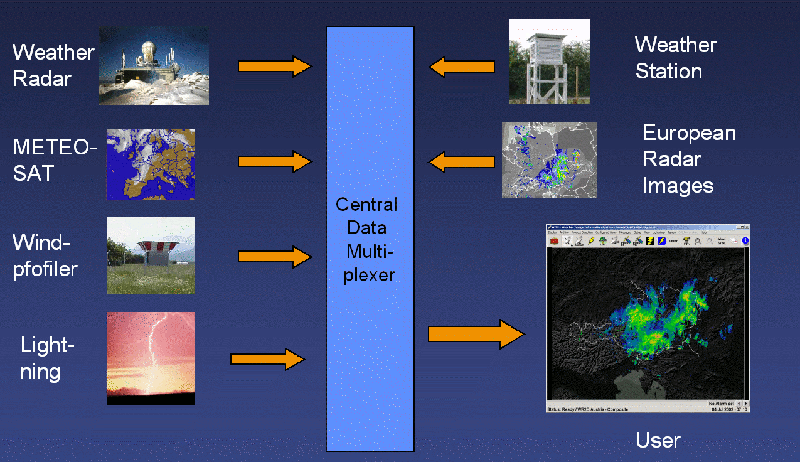
Figure 1: Network Configuration
WIIS is based on a client-server architecture (Figure 1) consisting of two main parts: A server-task receiving incoming data from the radar stations or Meteosat receivers via
and a client-task which can run on the same computer as the server-task (standalone configuration without network as shown in figure 2) or on a separate computer. Of course, in the latter case the two (or more) computers need to be connected by some computer network.
This architecture facilitates the installation of multiple display stations (e.g. for flight control centers) sharing the same data base.
The server-task archives the incoming images in files with configurable sizes, calculates composite images, maintains lists of available images and allows clients to retrieve the image lists and image data. Multiple clients (up to some hundred - depending on the hardware configuration) are allowed to connect to the server simultaneously.
The client-task receives the requested images from the server-task and is responsible for displaying them on the graphics-screen. The client's features include: